By RAISE
A geodashboard designed to support urban decision-making
Smart cities take shape when technology enters decision-making processes and helps interpret the complexity of urban territories. Collecting data alone is not enough. It must be interpreted, connected and transformed into tools that support concrete choices.
Within Spoke 1 of the RAISE ecosystem, the University of Genoa is working precisely in this direction. The team has developed SEAGUL – Socio Economic Aware Governance (For) Urban Landscape, a digital geodashboard designed to support policymakers and technical staff involved in building more inclusive, sustainable and aware cities.
The origins of the SEAGUL project
Explaining the development of the platform is Monica Bruzzone, researcher at the University of Genoa, who brings a strongly multidisciplinary perspective to the project.
“I joined RAISE as a research fellow,” she explains. “But our group’s work actually started earlier, with Professor Paola Dameri from UniGe involved in building the ecosystem. From the beginning it was clear that the university’s role would be central: bringing together different skills and directing them toward tools that are truly useful for the territory.”
SEAGUL was born from this approach. Not as a simple data repository, but as a platform capable of connecting territorial information, urban services and people’s needs to return an integrated view of the city. The goal is to make data readable, locate it at the neighborhood scale and transform it into a concrete tool for decision-makers.
“We didn’t want to build an analytical data bank,” Bruzzone adds. “From the start the idea was to create an operational tool that could enter the daily processes of public administration, but oriented toward medium- and long-term policies that have a real impact on people’s quality of life.”
A multidimensional dashboard for public administrations
“In recent years many urban dashboards have been developed focusing on highly analytical and specific data, often related to traffic or pollution,” says Professor Paola Dameri. “SEAGUL stands out because of its multidimensional approach and its multi-year time horizon. This allows structural decisions that will affect the city and its community over the long term. Making the right decisions is essential, also to use public funds efficiently and effectively.”
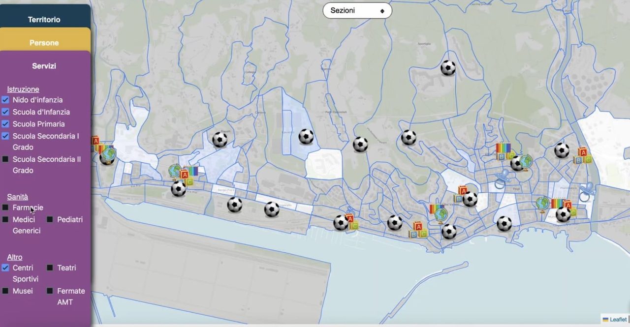
At the core of the project is a dashboard designed for public administrations, both for technical staff and political decision-makers. It is a digital space where different datasets interact and provide a dynamic reading of the city starting from the neighborhood scale: distribution of services, social characteristics, mobility patterns and urban configuration.
“The platform allows us to see the city as a system,” Bruzzone explains. “Territory, services and people are not separate elements. They constantly influence one another. Connecting them helps understand where to intervene and how.”
Planning urban services with data
To clarify how the platform works, Bruzzone offers a practical example: the work of a city councillor responsible for educational services.
“Think about planning childcare facilities,” she says. “It is a complex decision for a municipal administration. It’s not enough to know how many children live in a specific area. You also need to consider mobility, the presence of services, the urban layout and demographic changes.”
Through SEAGUL, decision-makers can observe the city from multiple perspectives at the same time. The dashboard shows where schools and educational services are located, how families are distributed across neighborhoods, daily mobility flows and the role played by transport systems and public spaces.

“At that point the decision is no longer based on impressions,” Bruzzone continues. “Patterns become visible. Imbalances emerge. You can understand where demand is growing and where supply is falling behind.”
For instance, a neighborhood may show a growing number of families with young children but lack nearby services. In other cases, existing facilities may be difficult to reach due to mobility patterns or urban design. Data may also reveal less visible situations, such as latent demand that could become a critical issue over time.
“The platform doesn’t make decisions instead of the administration,” Bruzzone stresses. “It provides the elements to guide choices: activating a new service, strengthening an existing one, improving transport or redesigning urban spaces. It helps build policies that are coherent over time and space.”
A technology designed to evolve with cities
SEAGUL is conceived as an evolving tool, designed to grow together with the city. Its effectiveness depends on data quality, platform maintenance and the training of those who use it.
“It is a living technology,” Bruzzone notes. “Training is needed to interpret and use it properly. Data must be constantly updated and the system continuously improved. Only then can it become part of everyday work.”
The project was developed within the UniGe component of RAISE in a multidisciplinary environment. Economists, computer engineers, architects and legal scholars collaborate to address urban complexity from different perspectives.
“The Department of Economics works on the framework,” Bruzzone explains. “DIBRIS develops the operational and engineering side, the Department of Architecture and Design focuses on social data and co-design, while the legal component works on proper data use and regulatory alignment.”
Data, citizens and artificial intelligence
Alongside quantitative analysis, SEAGUL also integrates a qualitative dimension. Living labs and co-design activities collect feedback from end users and citizens, allowing researchers to compare perceptions with objective data.
“We want to understand whether the reality described by the numbers matches what citizens actually experience,” Bruzzone says. “This comparison can help interpret territories more accurately and avoid partial readings.”
Future developments also include work on territorial clustering using artificial intelligence.
“We are exploring the possibility of identifying similarities between neighborhoods,” Bruzzone explains. “By feeding large datasets into the system, algorithms can detect patterns from social, infrastructural and service perspectives.”
The goal is to understand whether projects tested in one district could be replicated in other areas with similar characteristics.
“This aspect is still experimental,” she adds. “But it opens interesting scenarios: understanding where an intervention could have positive impacts even before launching it.”
Territory, services and people
The platform is built on a framework that connects three fundamental levels: territory, services and people.
“Territory is the foundation, the physical city,” Bruzzone explains. “Services act as the connective layer, and people are the core of the project. Reading these three elements together allows for more conscious planning.”
Within Spoke 1 of RAISE, SEAGUL represents a concrete example of applied innovation. Technology does not replace public decision-makers but strengthens their ability to interpret reality and act more effectively.
“The platform is designed to support those who make decisions,” Bruzzone concludes. “It offers a solid informational base and grows together with the city. Its value lies in its ability to evolve, adapt and accompany urban transformations.”
In this dialogue between research and public administration, a new idea of innovation takes shape: less abstract and increasingly rooted in local territories. Cities become spaces of continuous experimentation, where data, artificial intelligence and human expertise collaborate to build more inclusive and sustainable environments.